
Shinetsu Mountain Madness - Day 2
- Paul
- Jul 28, 2020
- 12 min read

Our run up and down Mt. Kurohime on Friday was just a warm-up for the bigger, bolder adventure we had lined up over the next two days.

The Plan
The idea was simple: we'd complete a 54 kilometer / 34 mile fastpacking circuit starting and finishing just up the road, at the "Amakazari-so" (雨飾荘) onsen ryokan, or traditional Japanese lodge. In order to do so, we'd need to run a counter-clockwise loop that kicked off with 18km / 11 mi of semi-paved forest road just to reach the trailhead, from where we'd merge with the proper climbing route that would lead us in the direction of our first summit - Mt. Myoko (妙高山). To actually set foot on the summit would require a multi-hour out-and-back detour, and once we completed that we would rejoin the dominant ridge and continue our traverse across the four remaining major peaks on our list; Mt. Hiuchi (火打山), Mt. Yake (新潟焼山), Mt. Kane (金山) and Mt. Amakazari (雨飾山). The entire effort should add up to approximately 3,700 m / 12,150 ft of elevation gain, which is a fair amount, but seemed completely doable over the total distance and would even be on the "easy" side relative to most long hikes in Japan. Listed map time was over 30 hours for the full course with an almost even split of 15 hours each day, so we anticipated knocking off the whole thing with relative ease in under 10 hours of trail time per day.

Since we would be spending a night camping along the trail, we needed to pack all the appropriate overnight gear and enough food for the two-day journey. In the end my starting pack weight was a bit heavier than I'd usually be happy with - weighing in at 7.8 kg / 17.2 lb inclusive of 2L of water as well as food, but I told myself it was ok because it was "only two days." The only facilities of any kind along the way would be a vending machine and toilet at the "Sasagamine" campground (笹ヶ峰キャンプ場) located at the entrance to the trailhead 3 hours in, and the "Kōya-ike" mountain hut (高谷池ヒュッテ) where we would pitch our tents at the mid-point of the trek. At the hut we would be able to refill water from an unfiltered natural source (snowmelt pond), buy bottled drinks and some basic snacks and use the toilet, but otherwise we had to be self-sufficient. Easy enough!
Starting Out
The usual last-minute gear checks and other random pre-trip madness dashed our hopes of getting to bed early in advance of our crack-of-dawn start. My head eventually found the pillow sometime after 11:30 p.m., a mere four hours before the dreaded but necessary alarm would buzz. Heavy rain persisted throughout the night, the sound of which would ordinarily have soothed me to sleep, but on this evening had the opposite effect - with each successive drop flooding my mind with unease about the weather we'd be facing starting out.
I flailed around in the dark in a desperate attempt to halt the unpleasant yet familiar beep suddenly and annoyingly interrupting my shallow slumber. It was 3:30 a.m. and time to get up, eat a small breakfast, change and make our way to the trailhead. I always find it hard to eat at such unusually early times, but made myself cram down a few mouthfuls to supply my body with some calories at the beginning - and put the rest in quick-access pockets so I could eat "caloric drip" style (little by little) on the go. We hoped to leave the house by 4:00 and be on the trail by 4:30, but we were predictably running behind. To our relief, by the time we did leave the house, the downpours that raged incessantly across the entirety of the evening had calmed to a refreshing light rain as we threw our backpacks in the car and made the 10-minute drive to our starting point.
I was honestly nervous for the road section right out of the gates. Not only was I shouldering a heavy pack, but I also hadn't run consistently in over a year due to a string of pesky injuries and the associated mental funk they caused. Add on the fatigue from the previous day's effort compounded with the pressure to keep up with my badass companions Derin and Luiz, and I wasn't exactly brimming with confidence. I told the guys I was going to approach the road stretch as a power hike vs. a run and to my relief they agreed. But I also have this weird compulsion to push myself at all times and at any cost, and it manifested itself right from the outset, this time with a simple suggestion rolling off lips: "Hey guys, let's just jog this first, short downhill bit."
The Forest Road


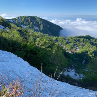
With our GPS watches set and our rain jackets on, the proverbial gun went off on our weekend adventure at 4:53 a.m. With the exception of the very first 400 meters / 1/4 of a mile, the opening 8 kilometers / 5 miles of road is a consistent climb, gaining 530 m / 1,740 ft to the "Otomiyama" pass (乙見山峠) that sits squarely on the border of Nagano and Niigata prefectures. The grade was manageable, and we kept a pretty decent pace by quickly walking and mixing in an occasional short jogging spurt. The rain was on and off, enough to be mildly irritating at times, but thankfully not worse. Just beyond the pass we encountered a giant and conspicuously out-of-place wall of snow completely blocking the road, but were able to climb up and over it without incident. Crossing over the curious snow wall felt like passing through a magical portal into another land, as views of the dense forests and imposing peaks of the "Myoko-Togakushi Renzan" National Park, mysteriously shrouded in low-lying clouds, immediately came into view giving us a bump in motivation and setting the imagination ablaze. With the scene in front of us, I almost expected to see pterodactyls soaring through the sky and the long, slender neck of a solitary brachiosaurus extending above the tree tops.
From that point the pavement that had brought us there abruptly transitioned to gravel, and we could now take advantage of the immediate gradual descent and upcoming flat sections as well as the more-forgiving surface to speed along to the trailhead. We did just that, covering the next 12 km / 7.5 mi in a half an hour less than we completed the first 8 km / 5 miles. We arrived at the Sasagamine campground at 8:18 a.m. and took a 25-minute break to fuel up with a bite to eat and help ourselves to some well-chilled Coke from the solitary vending machine on the edge of the vast, but empty parking lot.
The Over-Constructed Trail / The Calm Before the Storm


We left our break refreshed and ready to go, and only needed to cross the road to reach the start of the actual climbing trail that serves as the main gateway to Mt. Myoko and Mt. Hiuchi, two of Japan's "100 Famous Mountains." Presumably because of this, from the very outset the trail was far too manipulated by the hands of man for my liking. Unnecessary wooden boardwalks and series after series of carefully constructed staircases clashed against the natural landscape and completely dominated what seemed like the first several kilometers, wholly erasing the pleasure of walking in nature and replacing it with constant unwanted reminders of humanity's fickle, self-aggrandizing desire to "improve" upon imperfectly perfect nature. Perhaps that's just my opinion.

As we climbed higher, more and more the mountain trail began to resemble... well, a mountain trail - with hard-packed soil, exposed tree routes, and variously-sized loose and immovable rocks reclaiming their rightful place under our tired feet. After clearing the forest, we emerged into a wide-open marshland with multiple small ponds, a gently rolling river and a variety of late-spring flowers complimenting the scenery with the perfect splash of color. Little did we know that from this peaceful spot we were less than 15 minutes out from a literal and figurative turning point in our expedition.


The Inadequately-Maintained Trails / The Storm Before the Tempest
From afar it looked like a quirky, out-of-place observatory, and as we drew closer to the "Kurosawa-ike" hut (黒沢池ヒュッテ), we saw nothing to change that opinion. The building's bizarre spherical shape and deep-blue tin roof made little attempt to blend in with its surroundings. Due to the current situation surrounding the COVID pandemic, many of Japan's mountain huts have altered their operation periods and policies, or decided to remain closed altogether for the entire 2020 season. Kurosawa-ike hut falls amongst the latter, and fully looked and felt abandoned when we showed up just before 11 a.m., with random lumber, hoses and other objects hastily strewn about the grounds and no customers or staff in sight.

We stopped in the shadow of the blue dome to ingest some calories, refill our water bottles from the adjacent snowmelt stream, and review the map - since the out-and-back trail to the top of Mt. Myoko diverged from the main path here. Times listed on the map suggested it would take just over four and a half hours to reach the summit and return, but the total distance was a mere 4.4 km / 2.7 mi. We were confident we could easily knock off the whole thing in less than 3 hours - and probably even earlier since we decided to cheat and empty our bags of unessential items, deposit them near the hut and go as light and fast as possible with only rain gear, food and water.

From the hut the trail climbed over snow through a cluster of small trees before rejoining the summer route a bit further on. We gained 100 m / 330 ft quickly before dropping down slightly and entering a long, steep traverse. Not only was this path not the main approach to Myoko, but it had evidently been damaged recently - presumably during the recent heavy rains, or more likely from last year's monster fall storm, October's Typhoon 19. The trail was washed out in areas and littered with debris in others.

30 minutes in we encountered our first imposing obstacle; a small stretch of trail that had washed away with the mountain side, leaving only loose, crumbly dirt on a dizzyingly vertical face. First impressions were that it was too sketchy to attempt, but I started to feel that we could safely get through upon closer inspection. I volunteered to go first, and slowly and carefully made my way across, pointing out the few "safe" handholds and footholds to the other guys. Since the footing was so unstable we had to rely heavily on grasping and holding onto the vegetation, being sure to grab as many shoots of the fragile bamboo grass as possible at one time and avoid putting too much weight on any single plant. We made it through without incident and carried on buzzing from relief mixed with a surge of adrenaline.

That relief proved to be short-lived, the adrenaline however would be a near-permanent feature of the next few hours. Less than ten minutes after navigating our first complication we came face-to-face with our next, this time an intimidating traverse across a sharply-angled snowfield, where a single misstep could send us sliding out of control down its steep extent. We packed basic chain spikes in anticipation of the potential for some lingering snow, but we were without ice axes - a tool that would have been invaluable for what was now in front of us. I searched around for a sturdy stick to stab into the high side snow and serve as a third balance point during the crossing and set out first. I made a concerted effort to kick steps into the frozen ground as I progressed, but the rotten snow mocked my efforts by disintegrated and sliding away. Part of the way through my trusty stick turned traitorous as well, snapping in half and leaving me to balance wholly on the slick and unstable surface with just my feet.


I made it across safely as I knew I would, but the situation remained tense as I turned to watch my friends who were admittedly less experienced and less confident in these types of situations. Despite a brief slip that gave us all a good scare, everyone got to the other side unscathed - and we quickly and unanimously determined to avoid tempting fate by returning to the hut (and our gear) via this same way. Thankfully, a re-route would be possible, though it would tack an additional 2.9 km / 1.8 mi and take us on a trail that was marked with a dotted line on our maps, signifying that it would likely be unmaintained and "difficult to follow", in the words of the map company. We didn't care.


Deciding to go back a different way than we came eased our minds ever so slightly, but there was one last, potentially dangerous hurdle standing in the road between us and the summit. It was another vertical snowfield, but this time we'd need to head straight up it on our approach - and straight down it on our return. Without proper crampons and an ice axe we would need to tread carefully. All of these complications began to chip away at our pace and morale. In fact, midway up the climb at a point where the pitch uncomfortably steepened and we couldn't see the end or condition of the continuing snow section - one member of our party confided aloud that he felt we should turn back. I understood the concern and wanted just a little more beta to make the most-informed decision possible before settling on a course of action one way or the other. I told the guys to take a rest, and carried on with the ascent upwards to a point where I could scope out the bigger picture. To my relief it seemed that we were through the worst of it and soon to be out of the snow altogether. I told the guys what I saw and expressed my opinion that I would like to move on and felt we could do so safely, and eventually they gave the green light to continue.
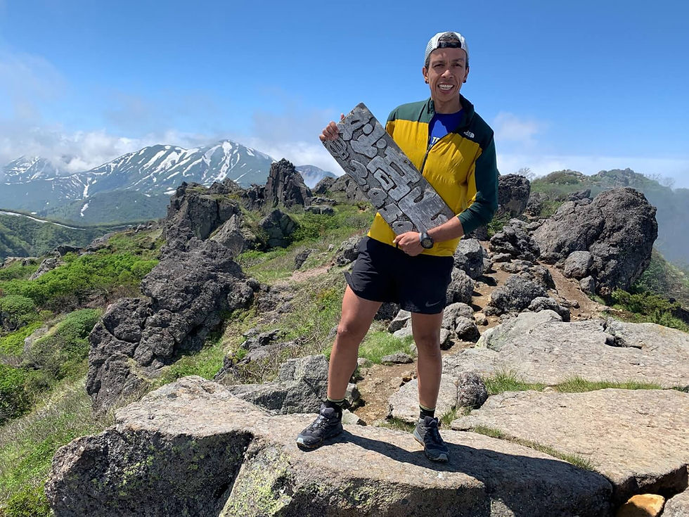


Once we cleared the snow, the trail before us was a refreshingly pleasant path winding through outcroppings of boulders and atmospheric forest, with some cherry blossoms even blooming above our heads so late into the spring. From there it was a quick but steep 30-minute scramble to Myoko's highpoint; the first of five summits on our list. The weather had been steadily improving throughout the day, and we were greeted with blue skies above us, though flurries of clouds still clung tightly to the surrounding peaks, cloaking their beauty in a whispy white veil. Since our return to our the hut would be along a roundabout route with uncertain trail conditions, we were careful to no spend too long lingering at the top. We commenced our descent around 1:40 p.m. and rejoined the snowfield within a half an hour and carefully made our way down to the trail junction (長助池分岐). The next 2.5 hours of map time would take us through unfamiliar territory, with the first 1.5 hours following an "unmaintained trail", but we all agreed it had to be better/safer than backtracking along the route that brought us here.


From the outset we were treading atop more snow and pushing through frequent thickets of small leafless trees, but the slope angle was manageable and posed no danger. Soon after, we reached a natural gully seemingly formed by the annual snowmelt and currently flowing with a healthy stream of calf to knee-deep freezing water. The pink ribbons dangling from the scraggly trees lining the banks meant that this was now our trail. Early on, from a combination of denial and a desire to keep our feet dry, we awkwardly and inefficiently hugged the bank, swinging from small trees and jumping from boulder to boulder... but eventually we were forced to give in to the circumstances and literally "go with the flow" by wading through and along the icy-cold brook. It turned out to be the most enjoyable part of the day, a novel, refreshing and exciting way to switch things up. We popped out briefly at onto a narrow wooden walkway cutting through a verdant marshland accented with alpine flowers, several small ponds and a clear view of Mt. Myoko - but were soon right back to sploshing through the narrow creek. Eventually we merged onto a single track dirt hiking trail and began to climb up to and ultimately along the ridge leading back to the hut and our belongings.


The Peaceful Conclusion to an Eventful Day
Finally, the hideous, bulbous blue apparition came into view: we were back. It was now almost 4:30 p.m., and we had fallen well behind our expected schedule, but luckily were less than 2 km from our destination for the day - the "Kōya-ike" hut (高谷池ヒュッテ). The day's final trail was heavenly; maintained, well-marked, scenic and enjoyable, with a 150 meter climb up to the top of Mt. Chausu (茶臼山), and a 50 meter descent into the lovely marshland surrounding the beautifully-constructed hut. We cruised into the hut at 5:10 p.m. concluding 12 hours and change of trail time for the nearly 40 km / 25 mi and 2,500 m / 8,200 ft of climbing on the day. This was several hours longer than we anticipated, but given all of the unexpected circumstances it was a decent result. We checked-in, payed for camping, set up our tents, cooked and ate our simple dinners on one of the picnic tables in front of the hut and got changed and ready for bed. We tried to dry our shoes, socks and insoles in the final, fading throes of daylight as we ate - but it predictably failed to produce results.


Temperatures dropped precipitously with the sun, and bottomed out overnight far, far colder than any of us had anticipated or packed for. And thus the long complicated day was capped off with an even longer sleepless night of shivering on my barely-there (8mm) foam mat, inside my paper-thin emergency bivvy lined with only a silk sleeping bag liner. Ah well, I think deep down we do these types of things in part because we like suffering; knowing that it builds character and resolve, reminds us how easy we have it in our day-to-day lives, and trips like this give us the rare opportunity to choose the hardship we face and control how we deal with it - a luxury we're not afforded 99% of the time. Oh, and also for the vivid memories and crazy stories (and blog posts) they are sure to inspire.
Link to this activity on STRAVA: https://www.strava.com/activities/3651541471
TO BE CONTINUED...


이용 과정이 간단하고 업무 설명이 명확해서 부담 없이 시작할 수 노래방알바 관련 후기도 많아 참고하기 좋았고 실제 근무 환경도 설명과 비슷해 만족스러운 경험이었습니다.
피곤함이 계속 쌓여 있었는데 관리 후 몸 전체가 한결 가벼워졌어요. 평택출장마사지 서비스는 예약 과정도 간단하고 응대도 친절해 기분 좋게 이용했습니다.
간편하게 이용 가능한 점이 가장 좋았고 혜택까지 더해져 일상 소비를 조금 더 합리적으로 상품권소액결제 관리할 수 있었습니다.
모바일로 간편하게 진행할 수 있어서 접근성이 좋았습니다. 상품권매입 과정에서 별도의 복잡한 인증이나 대기 시간이 길지 않아 편리했고, 처리 결과도 빠르게 확인할 수 있어 효율적이었습니다.
이동 시간 없이 바로 받을 수 있어 효율적이에요. 출장 서비스가 정말 만족스러웠습니다. 근육 이완 효과가 뛰어나 몸이 편안해집니다.