
Yake-Dake (Mt. Yake)
- Paul
- Oct 30, 2019
- 5 min read

We recently came back from a day-hike up to the summit of one of central Japan's most active volcanoes, whose name literally and appropriately translates to "burning mountain". Despite its colorful name and active status, it is currently listed at Level 1 on the 5-level Volcanic Alert Scale, meaning that there is a potential for increased activity within the crater itself, but no major climbing restrictions or threat of immediate eruption.

There are two possible approaches to the summit, one from the charming and secluded "Naka-no-Yu" hot spring resort, and the other from one of Japan's most beautiful and celebrated valleys - Kamikochi. The trail originating in Kamikochi climbs a brief, steep section that requires the use of fixed ladders, but those ladders are removed each year prior to the winter season making the route impassible between later October and early May. We set out to scale Mt. Yake on the 26th of October; two days after the ladders had been removed, so our only option was to begin our trek from the other side of the peak.
The Yake-dake trailhead is less than 2.5 hours from Otari where we are based, and the hike itself, while steep in places, is not a particularly long one. A roundtrip ascent is just under 7km (4 miles) and suggested hiking time is roughly 5 hours, meaning that we didn't have to rush to get a super early start, even this late into the fall season when daylight hours are steadily decreasing.
We left Otari just after 5am and were at the trailhead before 7:30am. It's a pleasant drive, particularly the latter half, and the peaking fall foliage stretching across the mountainsides in every direction made the already beautiful scenery even more spectacular. The tallest peaks of the Northern Alps were shrouded in clouds, but the forecast gave us hope that they would reveal themselves before the day was through. We checked our gear, added the food to our packs that we had picked up from a convenience store along the way, and hit the trail with the usual sense of adventure and excitement that registers internally at the outset of each hike - even when returning to the same mountains again and again.


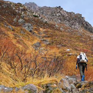
We knew we were missing the peak of the fall colors at higher elevations, but the leaves in the forest right at the outset were still dressed in surprisingly striking shades of reds, oranges and yellows that lured our eyes and camera lenses in every direction, and kept our progress slower than expected. We did eventually pick up the pace and moved quickly through the fog-filled forest on the steep, muddy trail riddled with tree roots. The summit of Mt. Yake sits at 2,455m (8,054 feet), while the trailhead from Naka-no-Yu begins right around 1,600m (a mile high). This means that hikers need to gain approximately 850m (2,800 feet) in elevation in a relatively compact distance, resulting in a tough average of nearly 270m climbed per kilometer.


After spending the first 2km in the cover of thick forest, the trail emerges into an open rocky bowl above the tree line, treating trekkers to their first view of the summit ahead, and the valley below. The hulking Mt. Norikura, a behemoth stratovolcano that rises above 3,000m, slowly comes into view behind you as you climb higher, while the massive peaks of the Hotaka range play peak-a-boo with you from behind the ridge of Mt. Yake. These small-scale glimpses of the large-scale beauty around you are the perfect carrot to keep you striving towards the summit even when your legs begin to tire from the steady ascent.


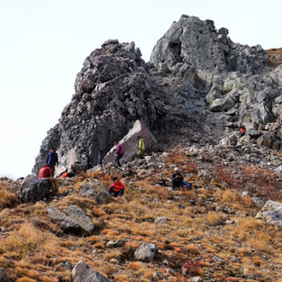
For us, it meant our pace slowed yet again as we snapped photo after photo and marveled for the millionth time at the beauty of Japan's mountains. The fog was rolling in and out, teasing us with wide-open views before slowly reclaiming them in curtains of white. Before long, despite our photo-induced leisurely pace, we had reached the final boulder-strewn approach that lies directly below the summit and passes startling close to an active sulfuric steam vent. It is fascinating to see the yellow-ish deposits of sulfur that stain the red rocks, and to pass through the putrid clouds of steam wafting across the trail. These little reminders that you are on an active volcano make the experience that much more unique, even before you reach the crater lake and superb views from the top.


Even with our picture-happy tendencies slowing our progress, we were soon snapping photos on the summit, less than 2 hours after setting out. We were also now considering potential options to extend our short day-hike to include more trail time, elevation gain and distance. This desire to continue was primarily influenced by the fact that the hazy morning skies had now mostly cleared. The panoramic vistas before our eyes, of snowcapped peaks rising above imposing walls of clouds and wrapped low and tight in a colorful blanket of fall colors, were counteracting any plans or desires we might have had to call it a day.

If the ladders down to Kamikochi had still been in place we would have aimed to complete the full traverse of Yake-dake, with the option to turn around and walk all the way back to our car. But no ladders meant to option to do so, and ultimately we decided to go as far as we could: we would descend the back side of the mountain in the direction of Kamikochi and head all the way to the Yake-dake mountain hut before turning around, scaling the peak a second time and returning to our car.
While the views from the top had been clear and interrupted, as we descended we were slowly re-enveloped in the same relentless clouds that had successfully stalked us on the other side of the mountain. The first kilometer of the descent is steep and done on a combination of loose rocks and big boulders, but we moved slowly and carefully through the fog and reached the hut without incident. The hut was already boarded up for the winter snows, so we borrowed some real estate on a bench outside to sit and down a few quick snacks before climbing back up another 350m to the summit and then making the descent back to the carpark.


Upon reaching the top for the second time, we found some large rocks to partially block the cold winds howling across the summit and took the time to have lunch while appreciating the special views before us. The wall of clouds was still present, but now slightly thicker, and moving in a mesmerizing flow towards the valley floor. I set up my iPhone and attempted to capture a time-lapse of the cloud choreography while I munched on my sandwich and enjoyed the live show. Lunch always tastes better in the mountains, and this day was no exception.


The time had finally come to head down, and the promise of finishing the day while relaxing in an outdoor hot spring bath was now the carrot that kept us moving in the opposite direction of the views that had motivated us on the ascent. "Onsen", as they are known in Japanese, are the perfect, unique, cultural compliment to a hike in Japan and a must-do way to wrap up an amazing day in nature.


Helloo. we are thinking of going for this hike. We are planning to go last week of May and Shin Nakanoyu for both ascend and descend. Had a few doubts though there will be no ladders/ropes in this route right ? Also do you know if there would still be snow in last week of May on this route as we dont have snow equipment. The site shows volcano level2 will we still able to hike ? Also Are there Any other permission we need to take ? If not any other suggestions for a beautiful hike (we will be in takayama) ? We are doing nakasendo trail as well, but was looking for one more with the mountains (day…